| |||||||||||||
|
Updated April 28, 2023
The Observation Search application lets you search for georeferenced observations of wild plants and see them on a map. It also show photos associated with observations. There is also a Place Name Search application to help find a particular location. |
|||||||||||||
| BASIC USE | |||||||||||||
To use the application, click on the
map in an area of interest  ,
zoom in, and press .
If you want to qualify what observations are returned,
enter some criteria, such as
Native Status = native. ,
zoom in, and press .
If you want to qualify what observations are returned,
enter some criteria, such as
Native Status = native.
Geographical Extent:
|
|||||||||||||
Or, open  POLYGON
|
|
||||||||||||
To find all records in a particular park,
press LAYERS
See also this introduction to Calflora Map Applications. For more information about background layers, see Map Layer Help. |
|
||||||||||||
| RESULTS | |||||||||||||
|
The results appear simultaneously in a table and as icons
on the map.
On the map, the default legend theme is | |||||||||||||
 Indicates a simple point. Indicates a simple point.
 Indicates an obscured point. Indicates an obscured point.
 Indicates a record with a line or polygon. Indicates a record with a line or polygon.
 Indicates a survey or checklist. Indicates a survey or checklist.
 Indicates a quad (for certain
plants in certain areas, only quad-level data is available). Indicates a quad (for certain
plants in certain areas, only quad-level data is available).
This icon applies when the value of Documentation is specimen:  Indicates a specimen record. Indicates a specimen record.
This icon applies when the value of Documentation is potential habitat:  Indicates a record of potential habitat. Indicates a record of potential habitat.
These icons apply if you have asked for zero count records or questionable records to be included in the results:  Indicates a record with Number of Plants equal to zero. Indicates a record with Number of Plants equal to zero.
 Indicates a questionable record. Indicates a questionable record.
| |||||||||||||
If you click on a point
on the map,
an InfoWindow opens at the point,
the table scrolls down to
the corresponding record,
and the record is highlighted.
If you click on the purple crayon
editor: Open Plant Observation Entry on this record. location-closeup: Open the Plant Distribution application showing a close up view of the record location. It will show the polygon associated with this record, if there is one, and any nearby observations of the same plant. comment (Calflora): Open the detail page for this record showing comments if any. If you are signed into Calflora you can add a new comment. This also works on CCH2 records.
|
|
||||||||||||
|
This application can show at most
2500 observation simultaneously.
If a particular search produces more,
the application will only show the first 2500.
Choosing Which Columns to Display
Photos

Sorting
|
|
||||||||||||
| SEARCH CRITERIA | |||||||||||||
|
Which Records are Excluded?
Scientific Name:
Typeahead enabled. Type the first few letters of the plant
you are looking for, and then choose it from the list.
Typeahead also works with Common Name.
Other Data Sources:
By default, a search from this application will
only
consider records contributed directly to Calflora.
Open
Photos: Choose records with photos if you only want to see records that have photos. Some records have more than one photo, and only the first one is shown in the results -- press detail to see all of the photos for an observation. Start Date, End Date: Use one, or the other, or both of these criteria to bracket the Observation Date of records you are interested in. Dates are entered in the format YYYY-MM-DD so that April 15, 2019 is written as 2019-04-15. If you enter 2019-05-20 as the end date, the result will include records that were entered on or before 2019-05-20. If you put the same date in both Start Date and End Date, the results will only include records entered on that date. County include surveys/checklists: By default, survey and checklist records are not included in the results. Check this box if you want them to be included. Location Description Some observation records have useful information in the Location Description field. Enter a short phrase to find any records that contain that phrase in the Location Description field.
MORE SEARCH CRITERIA For additional search criteria, open MORE CRITERIA.
Phenology: Some contributors specify the phenology (for instance, Flowering) of the plant when they enter a record. Use this criterion to find records with a particular phenology.
Location Quality: HIGH - MEDIUM - LOW.
Plant List: To limit your search to certain specific plants, choose a plant list. Look for already defined plant lists with the Plant List Definition application, or define your own. Click on the view link to see an illustrated version of the plant list.
Natural Status:
| |||||||||||||
|
Indexed After, Before: Use one, or the other, or both of these criteria to bracket the Index Date (date added to Calflora) of records you are interested in. Dates are entered in the format YYYY-MM-DD so that April 15, 2023 is written as 2023-04-15. Source: The source organization responsible for collecting the record.
Category:
The category of plants you are looking for. One of
Photo Contest Category:
One of
History Filter:
A history stack is a way of organizing
multiple records concerning the condition of a single patch over time.
In a history stack, all of the records concerning the patch are linked back to the earliest, or root, record.
When a history filter option has been chosen, a single record will be returned for
each stack.
only the most recent:
A single record (the most recent) will be returned for each history stack. Two columns appear at the beginning of the result set: Root and Most Recent. When historical information is available about a population, the Root record will be the oldest, and the Most Recent record will be the newest. When a history stack is not available, the record ID appears in the Most Recent column. (When there is only one record of a population, that record is both the earliest and the most recent.)
only reference records: Number of Plants:
at least one: (the default value) 1 or more plants were reported.
zero: 0 plants were reported within a certain area. any: Any value. include questionable records: Some observation records have been identified as questionable by Calflora users. By default, these are not included in the results. Check this box if you want them to be included. Documentation:
How this record is documented.
|
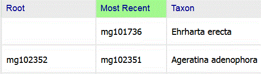
The Ageratina record is part of a history stack, and the Ehrharta record is not. |
||||||||||||
| LEGEND (AKA Symbology) | |||||||||||||
|
Open
LEGEND
In addtion to the default Record Type theme,
there are three other themes available: The Plant Name Theme
Once this theme is selected,
open
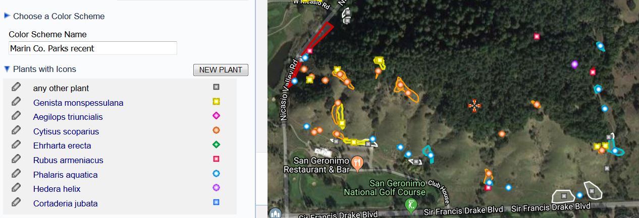
Plants with Icons to represent Rubus armeniacus.
Here is an example showing eight weeds recently mapped by Marin County Parks in the Roy's Redwoods Open Space Preserve:
Once you have assigned colored icons to particular plants, you can save your choices as color scheme, and use it again later. The Management Status Theme
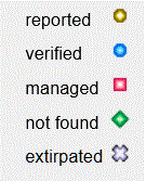
You can view observations acording to their management status using
the following icons:
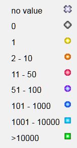
The Plant Count Theme
You can view observations acording to the value of
|
|||||||||||||
| SEARCHING WITHIN A POLYGON | |||||||||||||
|
Drawing a Polygon
Using a Saved Polygon |
in polygon | ||||||||||||
| SEARCHING WITHIN A BACKGROUND LAYER POLYGON | |||||||||||||
|
There are many background map layers available. If you select one of the following layers, you can search within the selected background polygon:
Protected Area (CPAD) Ecoregion Jepson Bioregion CNPS Chapter Zip Code USGS Quadrangle |
in selected area | ||||||||||||
| TOOLS | |||||||||||||
PHOTO ESSAY
DOWNLOAD RESULTS
Note that the Location Quality field is included in all downloads. If the value of Location Quality is high, the plant really was seen at the specified coordinates. If the value is medium or low, however, the coordinates indicate the general area in which the plant was found, and not a specific location. These records are useful for landscape level analysis of plant distribution.
Source and Citation should be included in any subsequent use of any downloaded record. For CCH records, the value of Citation is, for example:
Consortium of California Herbaria [CCH]. 2023. Specimen data from CCH contributing herbaria.
Retrieved from Calflora https://www.calflora.org/ Oct 01, 2023.
The value of Source is the abbreviated name of the herbarium. | |||||||||||||
|
SAVED SEARCHES
TOOLS
To see all of your saved searches
go to
To set up an email alert from a saved search,
go to
To use a saved search to load historical records into Observer Pro, go to
MyCalflora / Preferences / |
|||||||||||||
| EXAMPLES | |||||||||||||
Here are some examples illustrating the various features of this application.
 . .
All records (including questionable records) of Pseudognaphalium biolettii. Reported records and potential habitat records of Camissonia lacustris near Clear Lake. | |||||||||||||
| RELEASE NOTES | |||||||||||||
|
2022 April v 4.46
Natural Status is a new search criterion.
2022 March v 4.44 This application shows bryphyte data from the Consortium of North American Bryphyte Herbaria. 2021 October v 4.41 CCH2 data is downloadable. 2021 May v 4.36 This application shows data from CCH2 instead of from CCH1. 2021 May v 4.34 There is a PHOTO ESSAY function in the Tools menu. 2021 February v 4.30 There is a DOWNLOAD RESULTS function in the Tools menu.
2020 December v 4.21
SYMBOLOGY has been renamed LEGEND. To see the current legend, or to change legend themes,
open
2020 November v 4.19
Two new advanced search criteria:
2020 October v 4.17
A new advanced search criterion: Number of Plants.
2020 April v 4.04 The resize thumb -- a control to change the height of the map-- is back! Find it in the lower left corner of the map. 2019 July v 3.83. There is a new predefined column set called Basic + Accuracy which includes two fields that indicate the spatial accuracy of the record: Location Quality (low, medium or high) and Error Radius (meters). 2018 November v 3.49 In the table of results, all columns are sortable. Click once to sort in ascending order (green); click again to sort in descending order (orange). The column headers are pinned to the top of the page when you scroll down. 2018 September v 3.40 The Symbology control is available under TOOLS. 2016 August This application will only work with search polygons that have fewer than 3,000 vertices.
2016 July When you define a custom column set, it is stored in browser memory, and will be used the next time you use this application from the same browser,
2015 October When you select a plant list, a view link appears. Click on this link to see an illustrated version of the plant list. 2015 June History Filter included as a selection criterion.
2014 June
| |||||||||||||